It has been less than three weeks since President Donald Trump’s inauguration and the news is coming so fast that it’s hard to keep track.
Remember when we were all talking about Greenland? That’s so late January.
Two weeks ago, we were all worried about the new AI model from China, DeepSeek, and what it meant for the domestic AI megatrend.
Tariffs on Mexico and Canada? That’s so last week.
The truth is most of this is a distraction, and soon the news fizzles out.
Real proposals will have longer legs as they face hurdles in Congress or await funding before anything truly happens.
But there is one Trump agenda item making news that has universal backing.
Unanimity is rare nowadays, but everyone across the political spectrum is rallying behind this part of Trump’s agenda.
Follow the Money
According to Goldman Sachs, the United States will need to spend $500 billion by 2030 to build the electrical grid capacity and data centers required to support AI growth.
It wasn’t a coincidence that $500 billion is also the investment in Trump’ s Project Stargate, a joint venture that includes OpenAI, SoftBank, and Oracle. This initiative will build data centers and other AI infrastructure projects, and create more than 100,000 jobs in the U.S.
That dollar amount is tough to wrap your head around. To give you some sense of it, if you took a stack of $1 bills and laid them end to end across the length of a football field you’d have about $586. That’s easy to visualize.
And $500 billion laid end to end would go about 48 million miles. That’s about halfway between the earth and the sun!
You might be surprised to learn that those numbers are not unprecedented for U.S. infrastructure projects.
For example, to build the U.S. Interstate Highway System, the government spent about $114 billion over 35 years. In today’s dollars that’s more than $500 billion.
We all take America’s 48,890 miles of highways for granted, but it created huge economic opportunities.
Now, we’re going to need to spend that amount of money in only five years to build the energy capacity that will allow us to dominate an AI market projected to be worth more than $1.8 trillion!
How to Win the AI Race
China is our #1 competitor for that $1.8 trillion market, and the release of DeepSeek two weeks ago was a wake-up call: America isn’t guaranteed to win the race.
That’s why President Trump’s AI agenda has universal backing. Of course, the market can still be volatile as all this develops.
Here is what investing legend Louis Navellier wrote to his Growth Investor subscribers about why investors should keep a cool head:
The fears surrounding [DeekSeek and tariffs] were vastly overblown—and it’s time for Wall Street to shift its attention back to the fourth-quarter earnings announcement season.
The fact is fourth-quarter results have been impressive so far.
FactSet reports that nearly half of S&P 500 companies have posted results so far, with 77% of these companies posting a positive earnings surprise. As a result, the S&P 500 has achieved 13.2% average earnings growth in the fourth quarter, up from estimates for only 11.8% at the end of the fourth quarter.
Louis’ investment approach has always been based on staying exclusively in stocks with solid fundamentals.
His Growth Investor readers had already been steered into fundamentally superior stocks that are growing earnings during the AI megatrend.
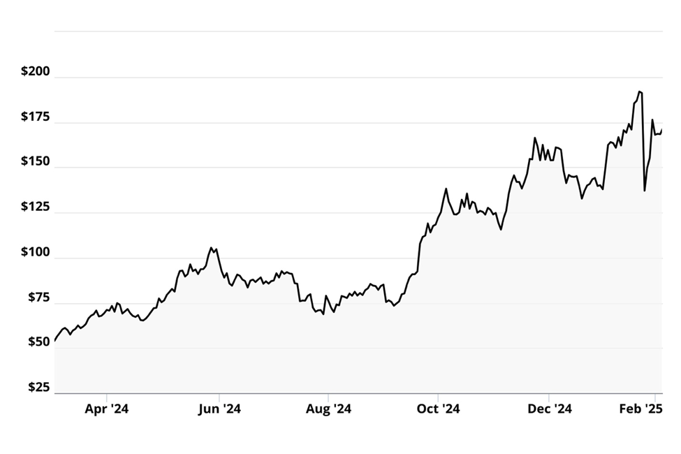
Some of the companies that were hit the hardest by the DeepSeek news were the companies helping to expand the electricity grid for new data centers.
That included some of Louis’ recommended stocks such as Vistra Corp. (VST) and Vertiv Holdings (VRT). Both were hammered on the Monday after the DeepSeek news, and they have yet fully recovered from these losses.
In the chart below you can see the hit Vistra took on the AI news two weeks ago, but you can also see that the stock is up more than 200 percent since Louis recommended it a little over a year ago.
It’s the same pattern with Vertiv. It was slammed two weeks ago but is still up almost 70% since it was recommended last March.
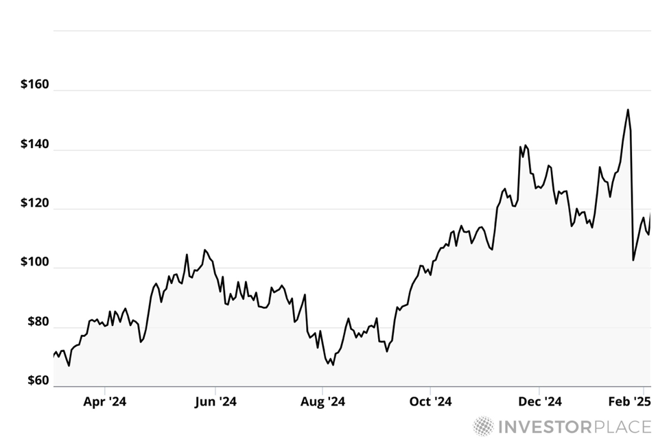
Both stocks are still below their buy up to prices in Louis Navellier’s Growth Investor.
Here is Louis’ advice for staying focused during volatile news cycles:
While it can be hard to tune out all the noise and block out the market distractions, if we stay focused on our fundamentally superior Growth Investor stocks, our stocks will continue to weather each market dip and positive earnings results should drive them higher in the upcoming days and weeks.
The Hottest AI Trend May Not Be the Obvious One
Another trend we will see during earnings season is that AI winners are not limited to the tech companies most people think about.
AI has been on the front burner for investors for more than two years. Most of the attention has been on bots like ChatGPT, Claude and now DeepSeek.
But many companies have been working to leverage AI’s benefits.
Hypergrowth investing expert Luke Lango has been watching, and living, this closely.
As to “living,” maybe you missed this video of Luke riding in a Waymo driverless vehicle in September.
Of course, AI is a key technology for autonomous driving – it helps these vehicles understand their environment, make decisions and navigate their surrounding environment safely.
Waymo is already operating in Phoenix, San Francisco and Los Angeles, and is going to expand to Atlanta, Austin, Miami, and Tokyo very soon.
But Waymo isn’t the only game in town, and the regulatory environment is getting better.
Thanks to President Trump and, likely, to his close advisor Elon Musk
Here is Luke writing to his Innovation Investor readers.
Reports leaked that President Donald Trump will work to ease the federal laws governing self-driving vehicles, making it easier for companies like Aurora, Waymo, and Tesla to massively deploy autonomous cars across America.
We earnestly believe that 2025 could very well be the year that the self-driving car went mainstream.
Of course, the arrival of the Age of Autonomous Vehicles also means the arrival of huge opportunities in AV stocks.
The global transportation services market is estimated at over $7 trillion, and autonomous vehicles will turn that entire industry on its head, meaning it could impact how more than $7 trillion flows through the global economy.
Luke has recommended three stocks to buy now for the self-driving revolution to his Innovation Investor subscribers.
These aren’t just the obvious plays of Waymo and Tesla.
These are the smaller companies that provide the software and other technology to Tesla and other car makers that makes self-driving vehicles possible.
Doubtless we will continue to see a ton of headlines about AI and tech in 2025. Investors have a unique opportunity – still – to get in front of this megatrend as it expands during Trump 2.0.
Enjoy your weekend,
Luis Hernandez
Editor in Chief, InvestorPlace
